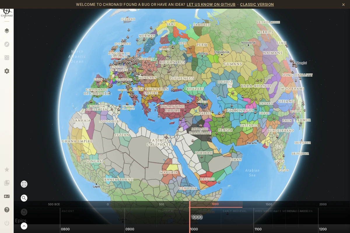
A curated selection of unique, niche, and fascinating websites in both Polish and English.
Welcome to the Cogimator.net Web Directory – a curated space for exploring unique and often overlooked websites. This is not just another list of popular platforms, but a hand-picked collection of projects that stand out through originality, design, storytelling, or unexpected utility.
This web directory features experimental interactions, visual gems, educational treasures, and cultural initiatives from around the world – all documented with descriptions, tags, and direct links. The directory is bilingual, offering separate sections for Polish and English language content.
Check back often – new discoveries are added regularly.
Future Timeline - Interactive Predictions Through the Centuries
Future Timeline presents one of the most comprehensive attempts to map humanity’s long-term future, stretching from our current century through to cosmic scales of time. This remarkable resource organizes predictions and speculations across multiple disciplines, from climate science and artificial intelligence to space colonization and the ultimate fate of consciousness itself.
The site’s structure is elegantly chronological, beginning with the challenges of our globalized 21st century—climate change, resource depletion, and technological upheaval—before expanding into increasingly speculative territory. The 22nd century explores diverging paths for humans and transhumans, while the far future contemplates post-biological humanity spreading throughout the galaxy. What sets this project apart is its serious engagement with both near-term scientific consensus and far-future theoretical possibilities.
...
OldMapsOnline - Historical Maps Archive and Explorer
OldMapsOnline represents one of the most ambitious efforts to digitize and catalog the world’s cartographic heritage. This remarkable platform brings together thousands of historical maps from libraries, archives, and collections worldwide, making centuries of geographical knowledge accessible through an intuitive timeline-based interface.
What sets this project apart is its sophisticated search functionality that allows users to explore maps by location, time period, and scale. The platform seamlessly integrates historical cartography with modern mapping technology, enabling users to overlay old maps onto contemporary geographical references. Each map entry includes detailed metadata about publishers, dates, scales, and provenance, creating a scholarly resource that serves both researchers and curious explorers.
...
This stunning WebGL fluid simulation transforms your browser into a physics playground where every mouse movement creates ripples of liquid color. Developed by Pavel Dobryakov, the simulation demonstrates sophisticated computational fluid dynamics running entirely in real-time through WebGL shaders.
The interface offers remarkable control over the physics parameters — adjust density diffusion to make colors blend more smoothly, crank up vorticity for more turbulent swirls, or modify pressure settings to change how the fluid responds to disturbances. The visual effects are equally impressive, with optional bloom lighting and sunray effects that make the flowing colors appear almost luminescent against the dark canvas.
...
Arcanum Maps - Historical European Cartography Archive
Arcanum Maps presents a meticulously curated collection of historical European cartography, with a particular emphasis on 19th-century materials. This digital archive serves as a bridge between historical scholarship and modern accessibility, offering researchers, historians, and map enthusiasts high-quality digitized versions of period maps that would otherwise remain locked away in archives and libraries.
The platform’s strength lies in its comprehensive coverage of European territories during a pivotal century of political and geographical transformation. From detailed city plans to broad national surveys, the collection captures the cartographic documentation of an era when Europe was reshaping itself through industrialization, nationalism, and imperial expansion. The interface allows users to explore these historical documents with contemporary ease while maintaining scholarly rigor.
...
Fortepan represents one of the most remarkable digital preservation projects in Central Europe, having grown from a modest collection of 5,000 photographs found at flea markets into a treasure trove of over 200,000 historical images. What started as a passion project in 2010 has evolved into Hungary’s premier community-driven photo archive, where memories rescued from forgotten drawers and attics find new life online.
The platform’s current spring release showcases 5,000 newly donated photographs from 30 contributors, with an exceptional focus on travel photography spanning from early 20th-century alpine expeditions to 1950s-60s European tours through Italy, West Germany, and France. These images offer fascinating glimpses into how Hungarians viewed Europe throughout different eras, while also revealing how foreign visitors perceived Hungary through the lens of a Swedish traveler’s 1935 photographs.
...
Hungaricana - Hungarian Cultural Heritage Digital Portal
Hungaricana represents one of Europe’s most ambitious digital heritage projects, serving as Hungary’s comprehensive cultural portal that makes centuries of historical materials accessible to researchers and curious minds worldwide. The platform aggregates content from major Hungarian cultural institutions, including the National Library, National Archives, and various museums, creating a unified gateway to explore the nation’s rich historical tapestry.
The portal’s strength lies in its diverse collection categories, spanning from medieval manuscripts and historical maps to folk music recordings and photographic archives. Users can navigate through the Budapest Time Machine to explore the capital’s urban evolution, browse extensive map collections that document territorial changes over centuries, or dive into folk music archives that preserve traditional Hungarian melodies. The search functionality allows both professional researchers and amateur historians to discover connections across different media types and time periods.
...
Orb.Farm presents a delightfully pixelated take on ecosystem simulation, inviting users to cultivate their own miniature aquatic worlds within a web browser. This charming digital terrarium combines the meditative qualities of fishkeeping with the experimental joy of building balanced ecosystems from scratch.
The interface reveals itself as both intuitive and surprisingly deep, offering an array of biological and environmental elements to experiment with. Users can introduce fish, algae, bacteria, and daphnia into their virtual aquariums, then observe how these organisms interact, compete, and coexist. The addition of physical materials like sand, glass, wood, and stone allows for creative habitat design, while environmental controls for oxygen and CO2 levels add scientific depth to the experience.
...
Radio Garden - Interactive Globe of World Radio Stations
Radio Garden transforms the simple act of radio listening into a mesmerizing journey around the planet. This beautifully crafted interactive globe presents thousands of live radio stations as glowing green dots scattered across a realistic 3D Earth, inviting you to explore the world’s soundscape with nothing more than a click.
The experience is delightfully intuitive — simply spin the globe, zoom into any region that catches your eye, and click on the pulsing dots to instantly tune into local radio stations. Whether you find yourself listening to morning news in Tokyo, folk music from rural Romania, or late-night jazz from a small town in Brazil, each station offers an authentic window into its local culture and daily rhythm.
...
Electricity Maps: Real-Time Global Grid Data Platform
Electricity Maps stands as the world’s most comprehensive electricity data platform, offering unprecedented visibility into global power grids across more than 190 countries. This remarkable resource transforms the complex world of energy data into accessible, actionable insights that span electricity mix composition, carbon intensity measurements, real-time pricing, and grid load information.
The platform’s true strength lies in its temporal comprehensiveness—users can access eight years of historical data, monitor real-time conditions, and explore forecasts up to 72 hours ahead. Whether you’re tracking renewable energy penetration in Germany, analyzing carbon emissions patterns, or monitoring electricity prices across European markets, Electricity Maps delivers standardized, harmonized data that makes cross-regional comparisons meaningful and reliable.
...
OpenTopography - High-Resolution Topographic Data and Tools
OpenTopography represents a remarkable achievement in democratizing access to high-resolution topographic data. This NSF-supported platform serves as a centralized hub where researchers, educators, and professionals can easily discover and access diverse collections of terrain data, including lidar point clouds, radar datasets, and digital elevation models from sources like the USGS 3D Elevation Program.
What sets OpenTopography apart is its commitment to simplifying the traditionally complex world of geospatial data. The platform integrates datasets covering over 500,000 km² globally, offering both web-based point-and-click access for casual users and sophisticated programmatic tools for researchers building automated workflows. The site features everything from detailed hillshade visualizations of Oregon’s coastline to 3D point cloud data of Colorado’s Flatirons, making complex topographic information accessible to a broad audience.
...